|
El Dorado County, California (version March 16, 2026)
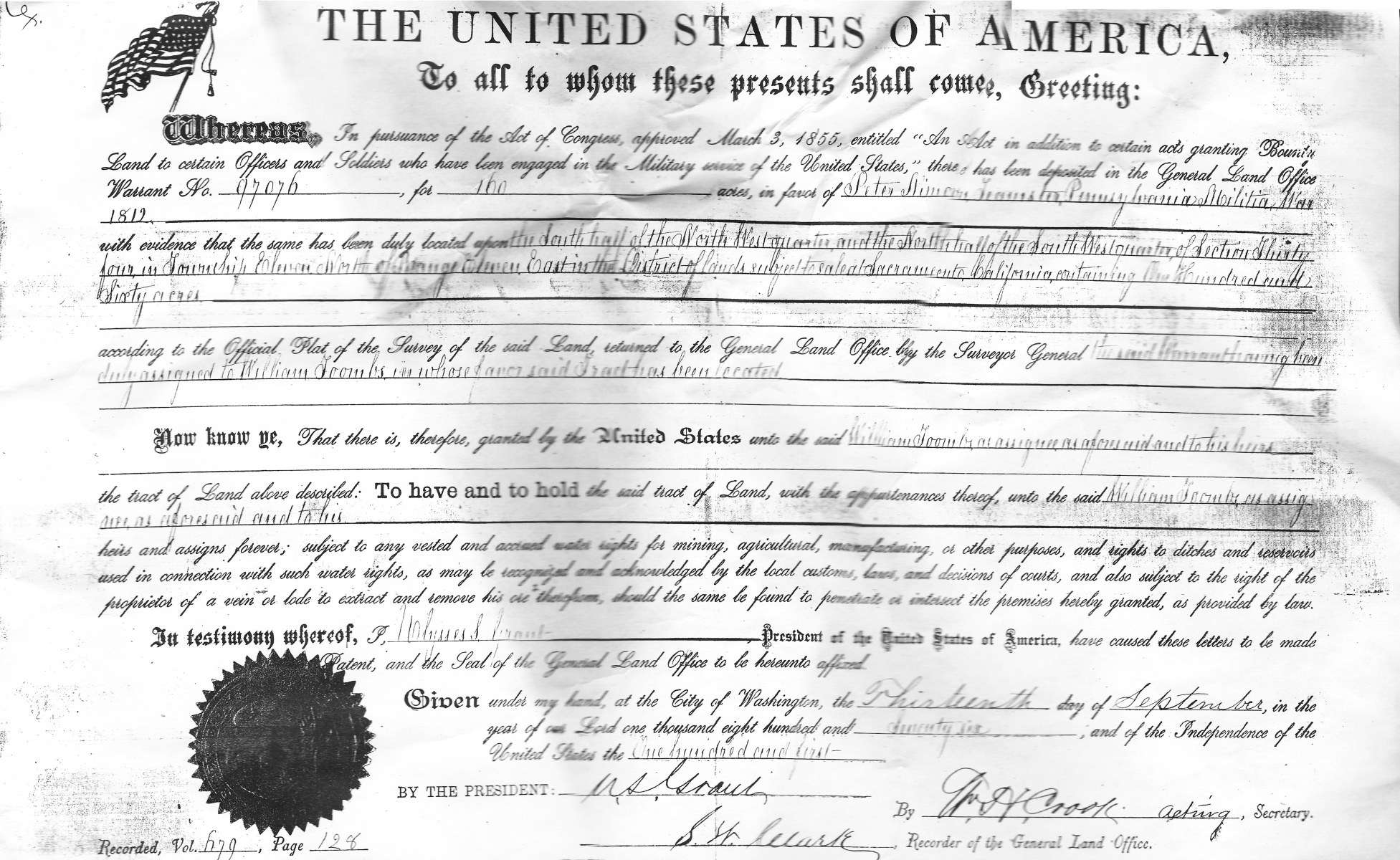
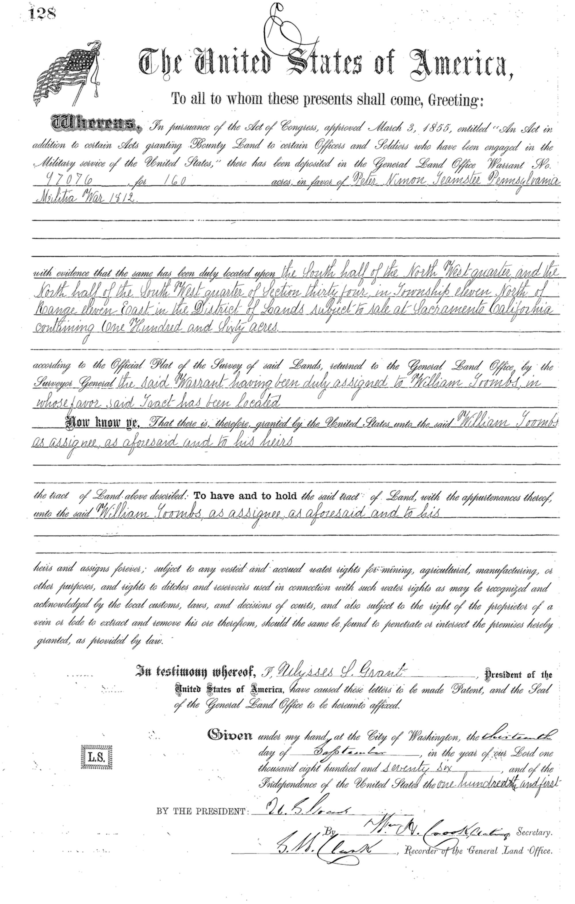
William Toombs bought from Alfred Briggs in 1866 the old Wooster Ranch, which we believe was probably an 80-acre land tract in White Rock Canyon in the N/2, SW/4 of Sec 34-T11N-R11E that was once owned by William Wooster (c.1812-1857) and his wife Mary. The Woosters had lived on this ranch, where they operated the Forest Sawmill, but when Mr. Wooster died on May 26, 1857, and was buried in the Old Placerville City Cemetery, he was in debt with a levy placed against the mill and property. Mary likely was forced to sell to settle debts, and Briggs probably bought the ranch from her as an investment. Briggs (1820-1907) was a politician, who from 1854 to 1862 served in the State Legislature for El Dorado County. He was also the local Federal Collector of Internal Revenue when he sold the ranch to William Toombs. William subsequently added 160 acres more to the north side of the ranch, when he received a Federal Patent (full ownership) on Sept. 13, 1876, with Peter Nimon listed as grantee, and William as Nimon's assignee (Land Office Doc ID #1127). This patent was obtained under the Federal Land Bounty Act of 1855, which awarded 160-acre land grants to individuals who had served in the U.S. Military during a U.S. War. Peter Nimon/Neiman (1786-1860) of Berks County, Pennsylvania, was a veteran who had fought in the War of 1812, and the Federal Government awarded him the land grant without his ever having to set foot in California. When he wrote his will in 1860 he specified that his real estate be sold by his heirs, who transfered/sold the land grant on June 24 & 25, 1874 for $200 to William Toombs. Because Toombs was still required to reside on the property, and make specified improvements, it was not until Sept 13, 1876 that he finally received full ownership of the grant. 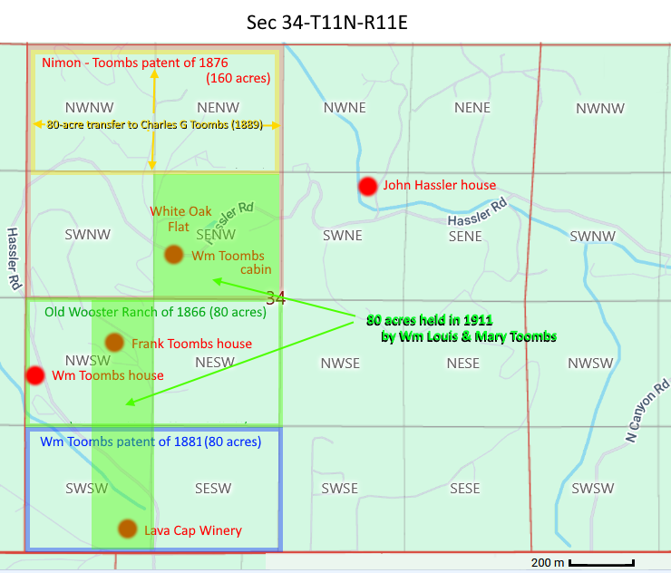
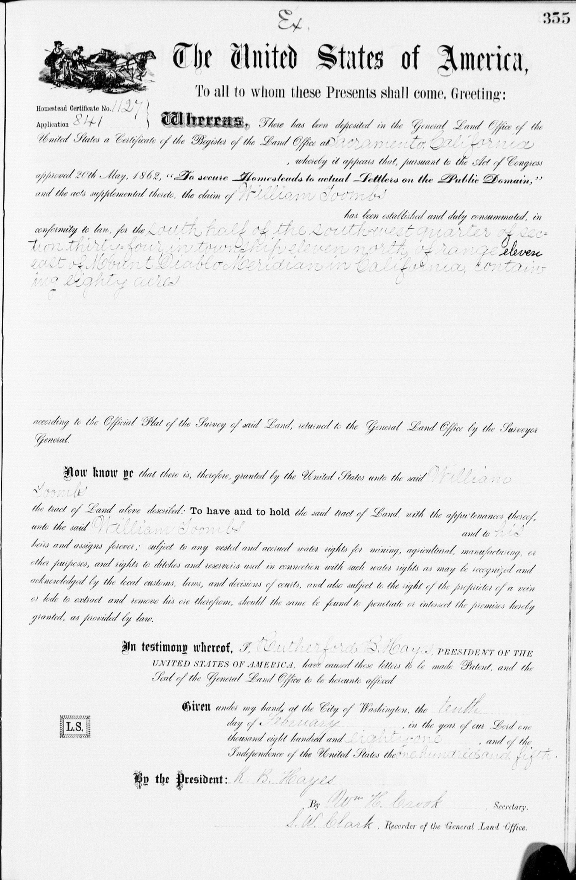
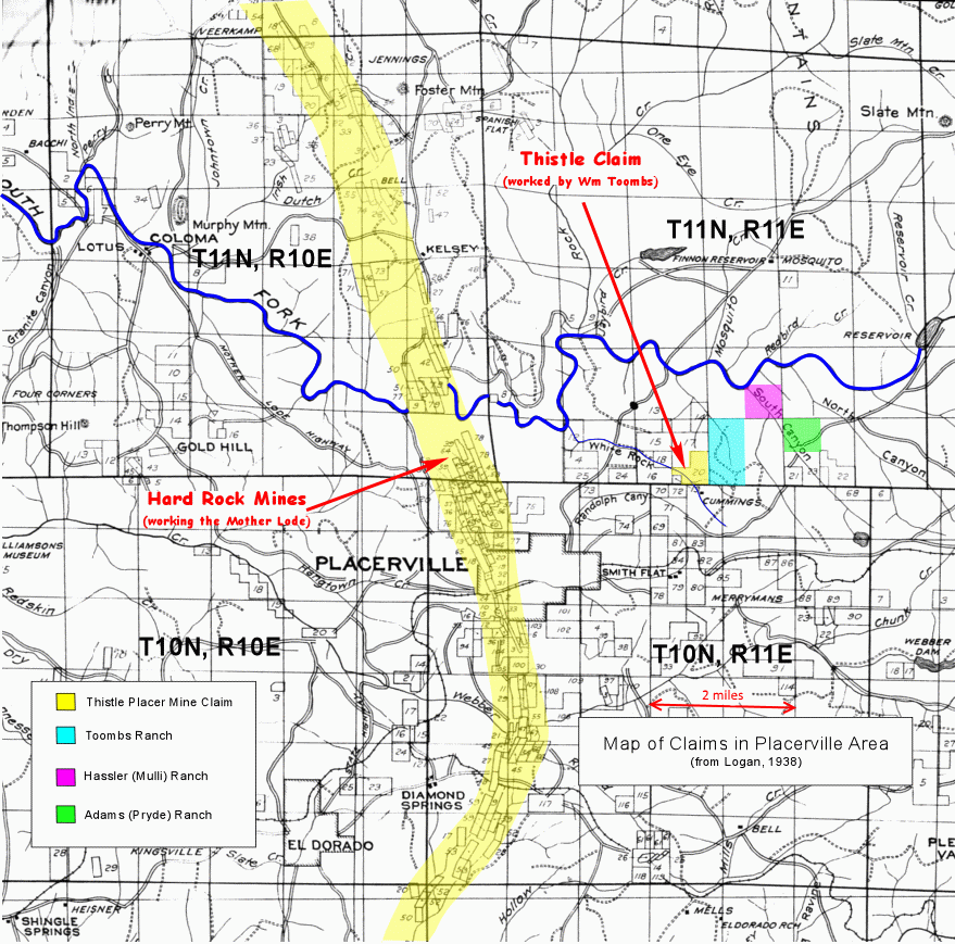
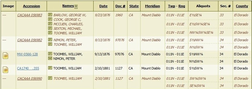
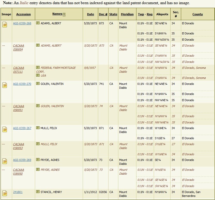
William then received a second patent on Feb. 10, 1881 (Doc ID #97076) for a plot of land on the south side of the ranch that increased the total acreage 320 acres. This patent was obtained under the so-called "Homestead Act of 1862", which awarded homesteads to U.S. citizens who resided on the property and made specified improvements to the land. This implies that either Toombs or William Wooster occupied the property in question fairly soon after then President Lincoln signed the Homestead Act. The ranch after this 1881 acquisition covered the entire W/2 of Sec. 34-T11N-R11E. The Woosters were forgotten, and the ranch became known as "Toombs White Rock Ranch" or as the "old Toombs Homestead". This is where William and Frances Toombs raised their children. A large part of the southern area of their ranch today is part of the vineyards for the Lava Cap Winery, which are located near the intersection of Fruitridge and Hassler Roads on the outskirts of Placerville. The Toombs Ranch over time was divided equally between William's two sons. The younger son, Charles Gilbert Toombs, received from his father in 1889 the northernmost one-fourth (80 acres) of the ranch, which he sold in 1890, just a few months later. Presumably, the older son, William Louis Toombs, received a similar parcel at this time as well, but we do not know this for sure. In any event, what remained of the ranch was somehow divided between the two brothers in 1892 when their parents died. We do know that William Louis Toombs and his wife in 1911 had at least 80 acres, or more, of the ranch, which included the SE/4 and E/2 of the SW/4 of Section 34. Charles Gilbert Toombs and his wife at this time had the old Toombs Ranch house, where he and his brother grew up, and where many members of the Toombs family were born. When Charles died he left what remained of his inheritance, including the ranch house, to his only son Albert, who is said to have lost it in a poker game in a Placerville bar. William Louis Toombs acquired his wife's interest in 1911 of parts of the Toombs Ranch that were in both their names, but he eventually sold all but a couple of acres of what lands he had in Placerville to his oldest son Frank Toombs, who planted the land in apple trees. Frank Toombs and his wife had no children, so Frank offered his apple orchard in the 1960s to his nephew Bob Carty, when Bob was looking for a farming venture to invest in, so that he could move his family out of Hollywood and into a rural setting. However, Bob declined the offer, and started a vineyard in Solano County instead. Sometime after the 1969 death of Frank Toombs, his wife sold what remained of the Toombs Ranch. Frank's fruit orchard was replaced in 1981 by a vineyard, and the Lava Cap Winery Winery opened up on the site five years later. William Toombs, Sr. was also a co-owner of the Thistle Placer Mine, in the SE/4 of Sec 33-T11N-R11E, which was located less than a half mile to the west of his White Rock Canyon home. This claim was made under the Mineral Law Act of July 26, 1866, which allowed U.S. Citizens and those who had declared their intentions to become citizens to stake claims to explore and occupy public mineral lands. William and four partners, one of whom was his son-in-law Michael Sexton, were awarded a patent (full ownership) on Sept. 23, 1876 to the 110-acre claim (Land Office Doc ID #1960). This mine was only two miles SSE of the White Rock Diggings, which was a hydraulic placer mine working the Blue Lead channel at White Rock Canyon. It is reported in Lindgren (1911) that the White Rock Diggings yielded $5,000,000 in gold (U.S.G.S. Prof. Paper 73, p. 172, 176-177). The Thistle Mine was also located just north of the Live Oak Placer Mine, where Thomas Ward and Robert Lowes, with a couple of partners, extracted several thousand dollars worth of gold. Thus, the Toombs claim was situated between two prolific gold mines. The Toombs family in 1905 still owned the Thistle Mine, when we read that "the Toombs boys property at White Rock has been bonded for $15,000 to C.E. Seymour." Presumably the "Toombs boys" refers to William's sons William Louis Toombs and Charles Gilbert Toombs. The tables shown below are from the website of the Federal Bureau of Land Management, and show the Toombs family land grants, with neighboring Federal land grants.
The United States of America
|